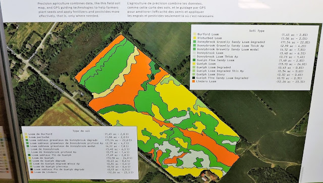
Sustainable and environmentally safe agriculture has been a big issue during the last decades. With increasing environmental awareness, there was a growing need for sustainable farming practices. Efficient use of a satellite in agriculture and minimising environmental impact became focal points for modern farming. So, how are spacecraft buses used nowadays to secure our future and keep the ecosystem intact?
Satellite Buses as Means to See the Full Picture
What
is a satellite bus? In space context, the term "bus" typically
signifies a satellite's main framework or structure that carries the load,
i.e., various instruments and systems used for data collection and
communication. The best spacecraft buses for agriculture are equipped with
remote sensing instruments, such as multispectral or hyperspectral imaging
sensors capable of collecting and providing accurate information. These sensors
capture data about crop health, soil moisture, vegetation indices, and other
relevant parameters. Satellite imaging agriculture solutions help farmers and
experts monitor and efficiently manage crops, predict yields, detect diseases
or even pest infestations, optimise irrigation, and make informed decisions to
enhance productivity and sustainability.
Spacecraft
buses for agriculture are common, but not a single utilization of them. The
imagery payload is also used in navigation, communication, urban development,
climate and weather monitoring, as well as national defence. But how exactly do
farmers benefit from satellite data?
What Are the Advantages of Satellite Imagery in Farming?
Satellite
imaging for agriculture has proven to be immensely valuable. It offers several
significant benefits:
- Precise Data: Remote sensing satellites provide highly detailed and accurate information about crops, soil conditions, and weather patterns, enabling farmers to take steps to improve their practice.
- Monitoring: Satellite data for agriculture aids in monitoring vast agrarian areas regularly, providing valuable data on crop health, growth, and potential issues like pest infestations or drought stress.
- Efficient Management: Farmers can optimise resource allocation, such as water and fertiliser usage, based on satellite farming technology data, leading to more rational resources and workload distribution.
- Detection and Preventing Potential Problems: Early detection of crop diseases, nutrient deficiencies, or invasive species allows farmers to take timely action, potentially preventing widespread damage.
- Yield Prediction: By analysing historical and real-time data from a satellite for agriculture, farmers can predict crop yields, leading to better planning and management of further distribution.
While
they're not a solution for every agricultural challenge, satellites with remote
sensing capabilities have significantly contributed to advancing precision
agriculture and improving agricultural productivity worldwide. Furthermore, the
first agriculture-focused satellite constellation, EOS SAT-1, was launched at
the beginning of 2023; hence, even more opportunities are to be anticipated in
the near future.
How Does Satellite Communication Contribute to Precision Farming?
Satellite communication contributes immensely by providing real-time data transmission and information exchange in remote areas. Sensors, carried by spacecraft busses, capture high-resolution images and data, and this information is accessible for analysis. Satellite internet services ensure connectivity in remote rural areas where traditional internet infrastructure might be lacking. This allows farmers to access online agricultural databases, market prices, and expert advice, which adds to satellite precision agriculture efficiency.
Machine-to-machine
communication between various agricultural machinery and devices, which
satellites facilitate, enables data sharing and coordination for tasks such as
automated planting, spraying, and harvesting. These tasks are also impossible
to complete without proper navigation, which agriculture satellite technology
provides access to.
How much do spacecraft buses for agriculture cost?
So
far, the utilisation of spacecraft buses for agriculture is more common among
large-scale enterprises due to the considerable costs associated with satellite
technology and data services. However, with technological advancements and
increasing demand, efforts are being made to make such tools more accessible to
smaller-scale or individual farmers. Some initiatives aim to create affordable
and user-friendly platforms or services that allow a broader range of users to
access satellite-based data for precision agriculture. As technology progresses
and becomes more cost-effective, there may be greater opportunities for various
types of farmers to benefit from satellite use in agriculture in the future.
Final Word: How Has Space Exploration Helped Agriculture?
Have
satellite buses really brought drastic change to modern farming? We were mostly
well before, and we still have some old problems to solve. However, with all
the possibilities space exploration gives, it is possible to significantly
improve general farming as well as shorten the time needed to fix problems.
Satellite agriculture mapping, constant weather monitoring, and studying
imagery to predict and prevent possible issues give us a chance we never had
before – to ensure that not only humanity but the planet itself will see a safe
and healthy future. Space technologies let scientists and experts see the
picture in its full complexity and tailor the best solutions to protect modern
and future generations from harm caused by the lack of knowledge.


.png)


0 Comments